My Monday got totally derailed.
This last Sunday evening, our neighborhood received word that our vendor who manages the prairie surrounding our community would likely be on site Monday to do some prescribed burning.
Fire in the ‘hood. Game on.
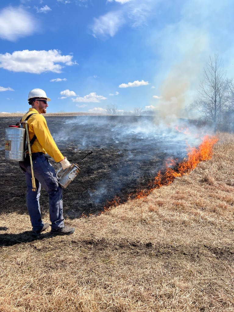
So Monday morning as I sat and attended yet another Zoom meeting, I looked out the window to see rising smoke from a portion of our conservation easement across the street. It had begun. I saw an individual with a brightly colored jacket walking between houses with a drip fire torch. I received an excited text from my neighbor across the street – “We have fire!!”
Over the next several hours, our vendor, NRS, burned approximately 30 acres of prairie. Once I finished my meetings, I quickly skipped outside and met up with the fire crew as they took a lunch break. I asked if I could catch some footage as they started the next section. I was given some quick safety tips, but the crew overall was fine with me sticking around.
The team of five moved efficiently across the landscape – two wore drip torches spreading fire and two manned ATVs with large water tanks in the back. Another member was a bit of a floater, but would stick somewhat behind to monitor fire trajectory. Every once in a while, walkie talkies would come out as the crew relayed where they were and the progress of the fire.
It’s a bit of a rush to watch somebody literally start something on fire when there doesn’t immediately appear to be a barrier that would stop that fire from spreading quickly and raging out of control. I mentioned that to the nearest crew member – he smiled, nodded, and said, ‘It is cool, but it is stressful, too.’
Weather conditions obviously play a huge role in whether these teams can safely burn – specifically wind and relative humidity. Winds between 4-12 mph can move the fire without too much risk, and having a consistent wind direction allows for the team to set a ‘backfire’ (or fire backing into the wind) and flanking fires (fires that parallel the wind direction) that help set firebreak boundaries before the team starts a ‘headfire’ (fire that moves with the wind direction). The fires then converge together in the middle of the target area and essentially put themselves out.
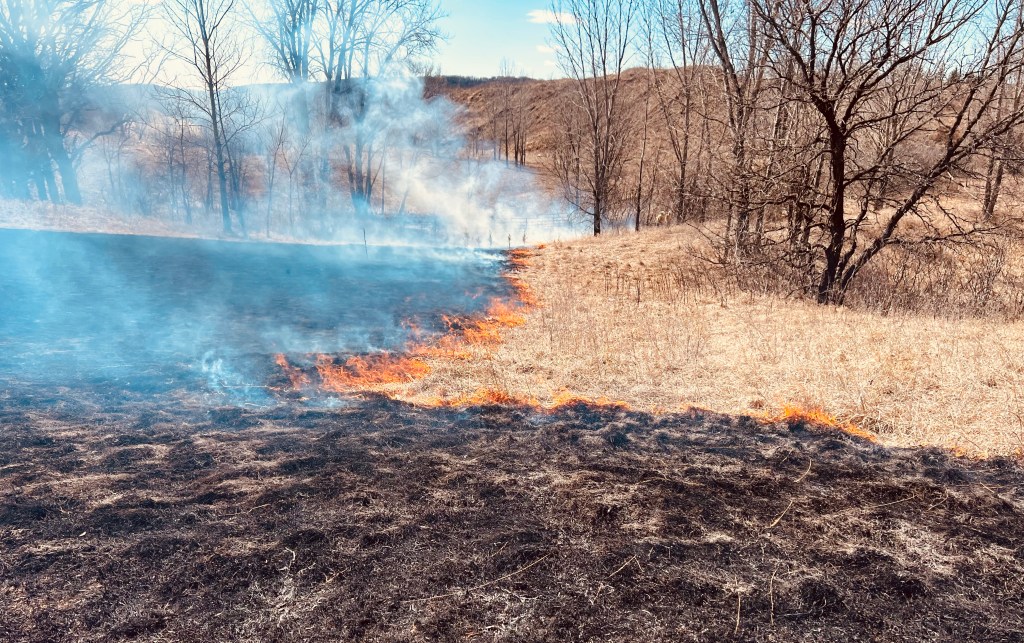
Relative humidity is also very important. Spring is known as being the ‘season’ for prescribed fires, because air temperatures are still low but relative humidity is high enough (between 25-50%) to prevent the fire from burning too hot.
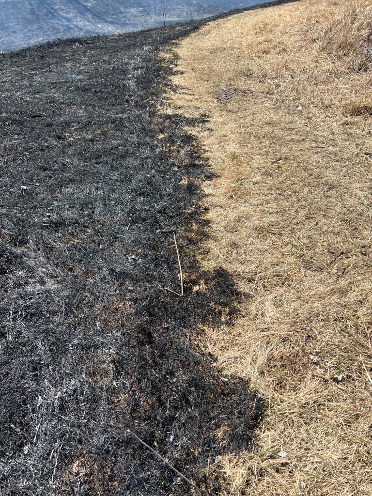
The precision of the burn was impressive. NRS stuck to the prairie property line and the edges of one of the the prairie trails. The ATV teams would reinforce firebreak edges by watering them down, and the team also preserved a few conifers by creating firebreaks around them. When my daughter and I took a bike ride later that evening, I was amazed at the extent of the burn – I felt like we were on another planet.
Why do we burn?
Fire plays an incredibly important role across many ecosystems, including forests, prairies or grasslands, and brushlands. In fact, many of these ecosystems have evolved to the point where they are dependent on regular fire disturbance to maintain their health and vitality.
In the case of prairies, regular fire disturbance promotes:
- Controlling the spread and growth of trees and woody shrubs that would encroach and shade out prairie plants, reducing available prairie habitat
- Regular clearing out of dead organic matter, essentially helping break down matter and return nutrients to the soil
- Increased sunlight access to the ground to promote young plant growth and warmer soil temperatures
- Increased biodiversity by providing food and shelter for a changing variety of wildlife
- Controlling and limiting the spread of invasive species that aren’t accustomed to fire disturbance (hello buckthorn).
Fires essentially are a reset button for the landscape, and it’s a reset button that both native flora and fauna have evolved to benefit from. While historically lightning was responsible for setting fires, before European settlement Native Americans routinely set fires as they recognized the landscape is better able to maintain and sustain itself with regular fire disturbance.
Problem is, since European settlement and especially in the last century, we have imposed an even bigger disturbance to these systems: fire suppression. We’ve generally had a zero-tolerance attitude when it comes to fire – we have homes and infrastructure and land uses that very logically, we don’t want to burn. Yet, that fire suppression has led to trees overtaking prairie and grassland habitats, forests becoming overgrown and full of potential fuels to create many of the megafires that have dominated news headlines in recent years, and invasive species are moving into and taking over these ecosystems relatively unchecked.
Prescribed fires have grown in use as researchers and practitioners have recognized that these managed, controlled fires can not only help reduce the risk of larger wildfires, but can be used to maintain and restore native grasslands and forests. It is truly amazing how quickly these landscapes can bounce back from a burn, because they have evolved to do so. This is a process I hope to capture in the coming weeks from our own neighborhood burn – stay tuned for pictures.
In the meantime, here’s some compiled burn footage to satisfy your inner pyro (to see some drone footage of the full burned area, skip to 1:58).
Featured image at top credit given to Patrick McNeil (www.mcneils.com).
