Last month, I was asked to speak in an elementary classroom about habitat fragmentation. The class had just finished an ecosystems unit, and the teacher wanted me to bring in local knowledge about ecosystems and how we humans impact them.
Immediately, I knew I needed to find historical aerial photographs from the area to share with the class.
When you’ve lived somewhere long enough, you notice the landscape changing around you. A favorite store closes or moves elsewhere, a piece of land is developed for a new supermarket, or a former family farm is converted into a new residential housing development. The change feels like it’s slowly creeping, but year over year, those small changes add up. Nothing brings it home more than looking at historic aerial photos.
When I showed the kids snapshots from 85 years of Bayport historical imagery, they were absolutely fascinated. Aside from the fact that many observed that the houses and neighborhoods they live in now didn’t exist until the last 20-30 years, they picked out immediately how much our landscapes have changed due to human activity. Roads, railroad tracks, and bridges dissect the landscape into orderly grids and/or amorphous shapes. Natural areas of prairie and forest were converted into farm fields, housing developments, and/or commercial/industrial infrastructure.
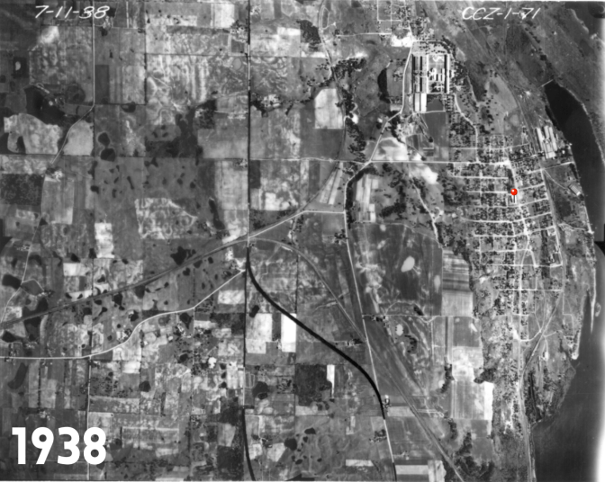

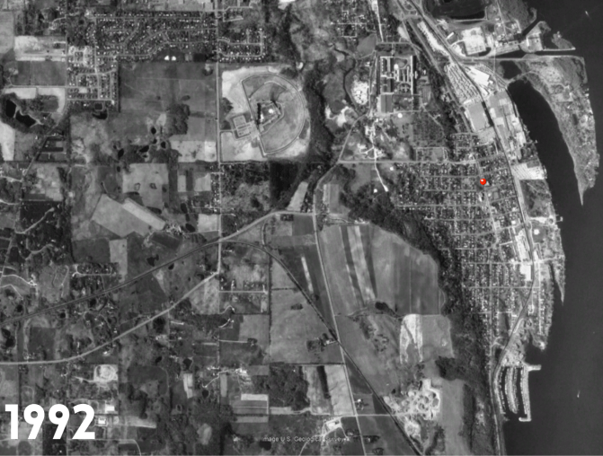
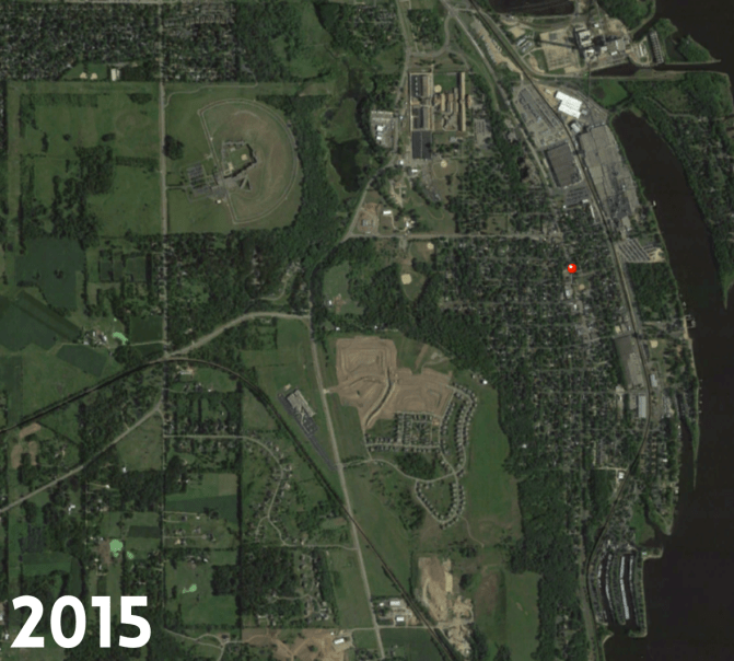
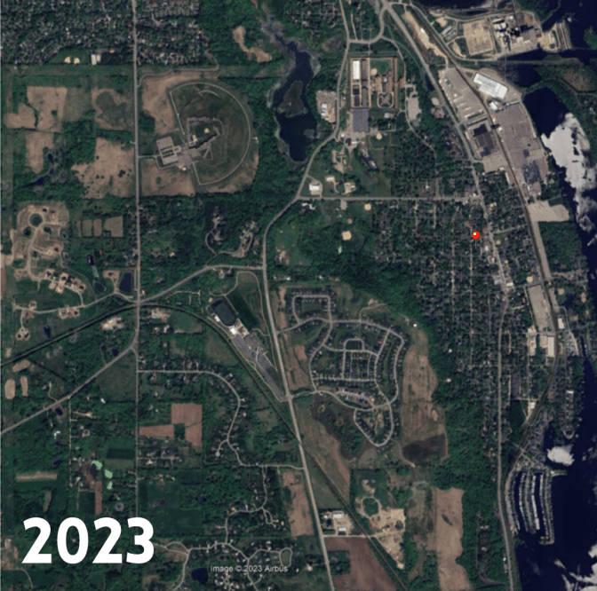
Above: Google Earth aerial photography of the Bayport area, starting with 1938 and moving through 2023. Red dot indicates approximate location of Bayport Elementary School (built in 1919).
Seeing all of that change in just a few clicks on the computer screen made it very clear when I asked the kids a couple questions: With all of this change, what has happened to the local ecosystem? Where would our native species, particularly our animal species, go?
The class got quiet as the implications of our ongoing human ‘settlement’ starting sinking in. Then the room burst with noise as kids started trying to tell me of all the wildlife that still is here.
“I see rabbits all the time!”
“There was a deer in our yard the other day!”
“”I saw a turtle on the road last week!”
“There are turkeys everywhere!” (This one was my favorite, because 50 years ago, there weren’t turkeys ANYWHERE in Minnesota.)
Still, they readily admitted that no, there probably aren’t as many animals around here as there used to be, and yes, when humans take up space, we are reducing the available habitat for many animal species. We talked about how there are some native species that used to be around here that they’ve likely never seen – the eastern spotted skunk, the prairie vole. We talked about how some animals can’t move easily or quickly (like turtles), so they may not be able to adapt if they lose their habitat. We talked about needing connected corridors of habitat, especially for animals near the top of the food chain that need more space to survive and thrive.
One child looked at me fearfully and told me that his family enjoys hunting – is that bad? No, I told him, because we don’t have the number of predators at the top of the food chain as we did once (fewer mountain lions and bobcats these days!), and we do need to control the numbers of some species to help keep some balance. He sighed with relief.
And there were a few questions posed that I didn’t expect. One kiddo asked about why a housing development was shaped as it was. Another wondered why we need ‘so many roads.’ It was interesting to see their observations of what ‘made sense’ and what didn’t, given the unique bird’s eye view of the photographs.
And then I got an amazing question: “Who decides how land is used?” That kid got a high five. We talked about how communities develop and grow, how city councils and planning commissions work to bring in more people and businesses. We talked about how community leaders help set the rules for how are spaces are developed and the importance of preserving the beauty and function of our native ecosystems.
It was a very fun class, all inspired by some historic aerial photographs. Ironically, it also corresponded with the release of a new video for local elected officials that was developed by our Lower St. Croix Watershed Partnership, in collaboration with the East Metro Water Resources Education Program (EMWREP). “When Development Comes To Town” tackles some of the challenges and opportunities presented by growth in our communities and makes the case that having a strong natural resource inventory of your area is imperative to help make good decisions about where and how development should happen. It’s a 10 minute video, but I guarantee it will fly by quickly!
AND ALSO, we need your wildlife photos!
On the topic of wildlife, Hannah Peterson, one of our AmeriCorps Community Facilitators has been hard at work creating a story map highlighting wildlife sightings around Washington County. She recently created a great story about the Turtle Tunnel in northern Washington County, and is interested in collecting more wildlife photos. If you have any photos to submit, she would welcome them. Please upload at https://form.jotform.com/233245041017039
Top photo: Drone photography by Patrick McNeil (www.mcneils.com)
